
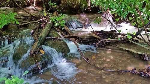
The Stamey Branch going at full throttle
A few of you have worried that the Blind Pig family might have been hurt by the horrendous flooding that’s happened in Western NC over the last week. We have been just fine with nothing more than a washed out driveway to worry about. Others in our county haven’t been as lucky. According to local officials Lake Chatuge, which is about twenty minutes from us, is higher than it’s been in 40 years. The TVA has been opening the flood gates which in turn has caused flooding for folks who live along the Hiwassee River.
Other TVA lakes in the area have also had to open their gates to release the excess water.
The local radio station reported that Murphy received 7.1 inches of rain during the month of May. More than a few people living outside of Murphy reported 10 inches of rain for the month.
Ken Roper said Nantahala Lake had it’s gates partially opened to let some water out and that the Nantahala River Road was closed from flooding. Ken’s friend’s son had to drive an extra hour and half to get home another way. One of my friends lives in the same general area and she and her husband drove for two hours across Rainbow Springs to make it to their house. She wasn’t at work the following day so I’m guessing they’re still suffering from all the extra water.
Don Casada shared this about the flooding:
“The other night, they noted on Channel 13 out of Asheville that we’d had more rain this month than any in recorded history, breaking the monthly rainfall from August, 1940. Although they didn’t realize it apparently, August 1940 was when we had tremendous flooding in WNC.
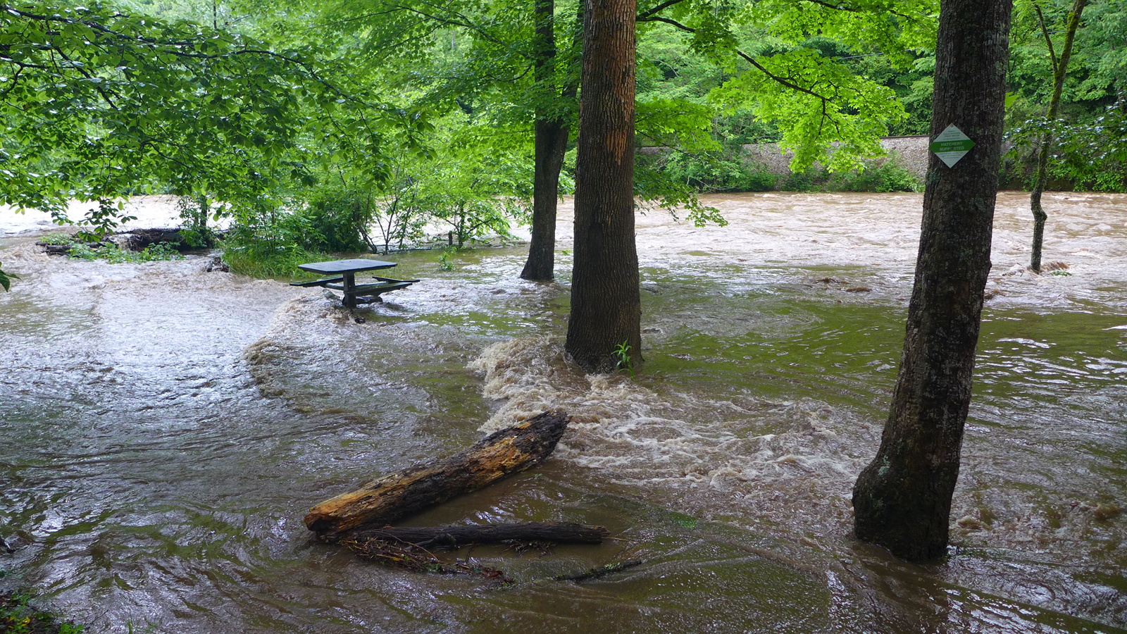
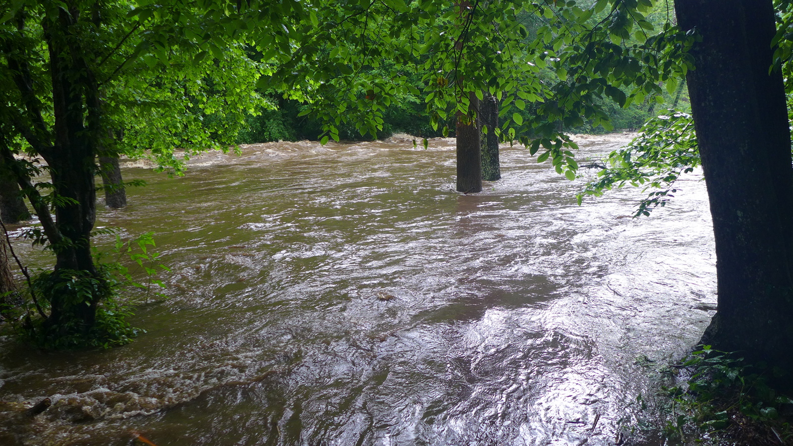
Susan and I drove over to Marble on Wednesday. The Nantahala River had been unleashed; I’ve never seen it anything remotely like it was. I got a few photos and a bit of video:
http://www.diagsol.com/Photos/P1070040.MP4
http://www.diagsol.com/Photos/P1070021.JPG
http://www.diagsol.com/Photos/P1070022.JPG
For those not familiar with the area, flow in this section is regulated by a dam, so they must’ve been bypassing some. I also don’t recall ever seeing the river ever being so muddy.”
———-
Hopefully the rain has moved out and things can get back to normal once folks get the mess cleaned up. I’m always reminded of the waters of the mighty deep when wet weather occurrences such as this one happen.
Tipper
Subscribe for FREE and get a daily dose of Appalachia in your inbox

I’m so glad everyone made it through and I hope the highways are cleared up by next wek when we go through the area!
Glad y’all are okay. We’re in White County, GA, and it was the worst we’ve ever seen. A new creek arose between us and our neighbors and flowed out of the woods right onto our road. More rains then changed the course of the creek, and yesterday it was running right down the middle of the road. Our road is completely torn up, and we can’t get out of our driveway. A large tree fell across the road and into our yard, broke our fence apart and destroyed my favorite tree in the yard. Thank goodness it’s over (I hope).
Dont want to abuse the “worse Ive EVER seen” thing but we’ve certainly had flooding rain. It was running off my eight back steps , from top of mt, like a river last night. The sound of water just hitting the ground was almost deafening. My dogs were scared to death and I have two trees down.
At least we have communication now, and forecasts etc. Ive heard the ‘old folks’ telling stories of floods in 20 and 30s , specifically Lake Logan area, washing out all bridges and my grandparents had to help bury the dead people washing out the coves, making caskets and digging graves because funeral homes couldn’t get up there.
Hurricane Ivan did a job on Haywood Co few years ago.
Its now raining again and dark and 3:50 PM.
Stay safe.
I got to doing a little googling and came up with some interesting facts. The water in Nantahala usually stays at around 3035 feet. The level of Fontana at Wesser where the water from Nantahala ends up is around 1703 feet. The distance from the dam at Nantahala to the mouth of Wesser Creek at Fontana Lake is about 11 miles as the crow flies. That means that a drop of water that runs over the spillway at Nantahala drops 1331 feet in that distance.
Now, that drop flows downhill into the Little Tennessee, the Tennessee and the Mississippi for about 1700 miles before it reaches 0 (sea level) in the Gulf of Mexico. This means it loses 44% of its elevation in just about 11 miles which calculates out to about .060% of its journey to the sea.
The Nantahala is called a river but would be more aptly called a series of waterfalls.
Tipper,
I bet up above the Powerhouse at the straight at Piercy Creek, probably the lowest part of the River Road, is gone and will need re-surfacing. I took your whole Family up in there Trout Fishing one time and you all caught a bunch of fish. I recon I’ve been all over the Nantahala from above White Oak to Tote N’ Tarries. (now the Outdoor Center) I’ve been caught on the far side of the River behind Jimmy Ferebee’s store (now the Tomahawk Trail) with the water coming on, fly fishin’, and losing all my flies getting back.
When it was Jimmy Ferebee’s store, he had a big brown Bear in a Cage nearby. Folks brought their dogs there to let them see and train ’em. One time a fellow stopped and showed the Bear to his 2 Coon Dogs. They took one look at that Monster and split the Nantahala behind the store and I don’t recon he ever found ’em. Me and daddy and some of my brothers were sitting in the car and saw it all happen. Then Daddy got out with ole Copper, but when he opened the door, they all poured out. We had four. Dogs don’t pay any attention to size, and they laid down on their sides and bit the Bear’s toenails. Fiests are real nervey anyway, and if old Copper caught you starring at him, he’d start growling, at anybody but Daddy. …Ken
Our branch got higher than I’ve ever seen it. It’s normally ankle deep, but my husband jumped in to mid-thigh to clear our culvert of limbs & bridges (pieces of plywood for the children to run across) to save our driveway. If it was the same amount as 1940, Morganton’s Greenway project has been a success, it’s been wild (& a tiny bit unnerving) driving over the Catawba & seeing how far out it came & the time it’s taking to recede.
Impressive photos. The “backward waves” which form as the water hits large rocks or other rises in the creek or river bed always fascinate me. Flood waters are powerful forces.
Y’all will have some good rock and other treasure hunting in and along Stamey creek when the waters recede. Do you ever make up or imagine stories to go along with your finds?
Hope folks in your parts are smarter than some of the folks around here who try to tube in the rushing waters. They not only endanger themselves but also would be rescuers and emergency personel who have better things to do than rescue fools!
Stay safe!
finally a sunny day yesterday here in Middle TN. We’re hoping to get some garden work done soon if the rain will hold off for a while.
Don’t forget boys, that Nantahala picks up a lot of water below the dam. Queens Creek, Piercy Creek, Camp Branch, Otter Creek, etc. Rowlin Creek drains all the way up to Topton. There are dozens of unnamed streams and rivulets that also feed the Nantahala below the dam. Even in the driest part of the summer water seeps from the rocky mountainsides in places.
It seems counterintuitive but those mountains made of stone are more like a sponge. They catch and hold water then release it slowly as multitudinous springs which then join together into larger streams. Also like a sponge, a little too much rainfall results in rapid runoff which is often catastrophic. In the mountains flash floods arise and dissipate quickly but leave a path of destruction caused not by the water itself but by the force that propels it down the mountain. People in the flatlands see waters that rise because it has no place to go except seeping slowly down into the soil. People in the mountains die in landslides while their counterparts in lower elevations die of diseases related to standing water. Either and both are equally dead but I would prefer the swifter of the two.
By the way it only came one quick shower yesterday and I got to finish the rest of my yard mowing right before dark. That is except for the ditch in front of the house which is normally dry but now has a mini creek running through it.
There’ll be some good rock hunting after these “Mississippi Log Rollers”!
Oh my goodness! Those pictures of the Nantahala River show just how powerful mother nature can get. You could be swept away in a nanosecond. I sure hope the rain ends and the sunshine returns to Western North Carolina and the rest of the east coast.
The rain pattern started here on Derby Day, setting a record for the wettest Derby in history. It has been a challenge to do farming and outside work, but thankfully we are not experiencing any major flooding. Glad you all are ok!
Glad you all are OK. Even our 107-degree weather seems less a burden because at least we are dry — but of course
we would love to have some of that 7-inch rain.
I can remember several years back we visited the Smokies, there had been a hurricane that year go across and all the trees that had slid off the side of the mountains from so much rain and wind, even after this rain ends the ground is so wet the first big wind could topple more trees, so yall be careful even just driving down the road can be dangerous for a while.
We certainly have had a remarkable amount of rain. Glad you all have not been greatly troubled. Water is surely the worst enemy of gravel roads. I expect the counties and the Forest Service have a lot of washed out road.
From your reports of what it means to residents for the river road to be flooded it isn’t too hard to think about how it would have been in the 1880’s or so. Flooding then would have been especially damaging to steep roads and valley bottom roads, as well as sidehill fields. Ganzy Keith, sawyer where I once worked, would say, “I have a bottomland farm. All the top has washed off.” Tragic but a lot of truth in it.
Tipper–We had a sunny day yesterday, after a May where I recorded well over six inches of rain in my gauge, and I thought that maybe with four of five days of that I might be able to set foot once again in my poor, battered garden with tomatoes desperately needing staking and weeds running riot. It wasn’t to be. last night we had 1.75 inches in about a 45-minute time span. I reckon I’ll be luck to have anything in the way of garden truck this summer.
I’ve never seen the Nantahala River anything like the photos Don shared. I reckon every trout from the powerhouse at the upper end of the gorge downstream will be washed down to Fontana.
Jim Casada
Tip, I think the the only thing that kept this from being as worse than 1940 was the rain spread out over a week instead of happening all in one day. I remember my aunt Ruth telling me that in the 1940 flood they put their shoes in the bathtub. The house was several feet from the ground and when the river (Pigeon River in Canton NC) broke out it it came in the house but did not come up to the top of the bathtub…so their shoes were saved!
My creek did not come out of the banks like it did my first year living here.
Water released is one of the most powerful things on earth!
If I don’t mow my yard soon I’m gonna have to bale the grass!
Glad to hear you all are ok, we didn’t get that much rain here in southern Ohio.
Wow, was this from Albert?
Sheryl-yes most of the rain came from Alberto.
Glad you are all ok. I’ve been seeing horrible flooding in and around the north GA, western NC and TN mountains. Hope the waters recede quickly and life returns to normal soon.