Today’s guest post was written by Don Casada.
_________________________________
Robert and Elizabeth Beck Collins – Pioneers of the Pioneer Church of the Smokies written by Don Casada.
Both Mount Collins and Collins Creek are putatively named for Robert Collins, but I hope I won’t appear at once both politically correct and patronizing to suggest that they are named for both Robert and his wife, Elizabeth Beck Collins. Married in 1830, the couple’s love and labors together bore fruit in children, community, and more broadly, across the range of peaks of the Great Smoky Mountains.
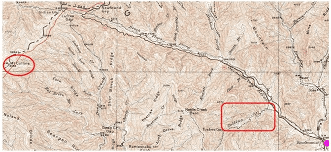
1931 Topo map of upper Deep Creek and Luftee. Mount Collins is in the ellipse; Collins Creek is in the rectangle. The Ocona Lufta Baptist Church is at the pink dot.
Robert and Elizabeth were among those present on June 6, 1836 in the home of Dr. John Mingus when the Ocona Lufta Baptist Church was organized with twenty-one original members. Robert Collins and Ephraim Mingus were elected as the first church deacons.
Robert was a toll keeper for the Luftee Turnpike, which ran up length of the Luftee, swung up across the upper end of the Thomas Divide (named for William Holland Thomas, a white Cherokee chief and leader of the Thomas Legion during the Civil War), and crossed the main spine of the Smokies at Indian Gap. Indian Gap is a bit over a mile west of Newfound Gap, and about 3 walking miles east of Mount Collins. You can still see much of the old road. I’ve walked parts of it; some is easy going, but in other areas, it is almost impossible to even see, let alone follow (severe rhododendron hells). On the Tennessee side, the existing Road Prong trail, maintained by Park Service employees who earn their keep as well as volunteers, pretty much follows the old road. During the Civil War, Confederate troops rolled cannons up the Luftee Turnpike, but the Tennessee side was so steep that they had to disassemble and slide them down. The Road Prong trail terminates near the Chimneys, a popular viewpoint in the Smokies.
A personal favorite story about Robert Collins is that he was the guide for Arnold Guyot, who first mapped the Smokies and measured the peak elevations in the 1850’s. The areas they walked are today traversed by the highest sections of Appalachian Trail. There was no trail at that time, of course. For anyone who has ever walked through that section and paid the scantest attention to what off-trail travel would be like, the thought of them doing it while carrying scientific equipment (not the lightweight stuff we have now) is mind-boggling. By the way, there is a mountain near Tricorner Knob, the most remote spot in eastern North America according to a study from the University of Tennessee, named Thermo Knob. It is so-named because Guyot dropped and broke his mercury thermometer there. Completely independent of the physical difficulties in getting around in this area, as an engineer whose cash-paying work involves field measurements in sometimes challenging industrial settings, I am awed by the quality of Guyot’s work. His estimates of most peak elevations were amazingly close to what modern measurements indicate. A fervent Christian himself, a factor which may well have played a part in his choice of Robert Collins as his guide, Guyot sought out excellence in all things: instruments, methods, and – in the case of Deacon Robert – guidance.
From 1808 until 1851, the Oconaluftee area was a part of Haywood County. Macon County had been formed in 1828, but its dividing line in this area was the next drainage to the west, following the meanderings of a creek then known as Newtons Mill Creek. Today, we call it Coopers Creek.
The 1850 Haywood County census indicates a 45-year old Robert and 41-year old Elizabeth Collins living in the Luftee area. They had brought forth abundantly in the earth, and living with them were six sons and four daughters. Neighbors included white families with long histories in the area – Mingus, Hughes, Enloe, Floyd, Conner, Bradley, Gibson, Carver and Beck, including Elizabeth’s parents John and Jane Swearingen Beck.
But there were also a large number of Cherokee Indians with a significantly longer area history and lovely, melodic, soft-sounding names – such as 90-year old bachelor (or widower) Honey su cah, Le to li che and his wife Cos ti you he, and a young couple, Hoona cho sah and his wife Coo ne les ce – living nearby.
Most folks, white and Indian alike, including Robert Collins, listed themselves as farmers, but there were millers, a medical doctor (John Mingus), and the Baptist minister of the Ocona Lufta Baptist Church (Jacob Mingus).
Mount Collins

A late view southeast from Mt Collins across Deep Creek to the far blue Balsam Mountains of Jackson County in the beyond. The somewhat flat-topped ridge in the photo center is part of the Thomas Divide, which separates Deep Creek and the Oconaluftee basins.
Mount Collins, fittingly named for Robert who guided Guyot across its peak, is the location of one of the most significant geographical markers in the Smokies, Meigs Post. That location was part of a line run in 1802 to define a disputed boundary line between whites and Indians (which, of course, kept getting shoved to the west as time progressed). A literal post was placed there by Return Jonathan Meigs, who had served as an officer in the Revolutionary War, on August 17, 1802. In his log for that day, apparently recording a statement he made at the erection of the marker, he wrote:
“Erected by the order of Thomas Jefferson the Supreme Executive of the U. States. The man who in Eloquent Stile & firmly collected attitude, in the Face of the Universe announced the Independence of the United States of America.
The undulation of his Voice made Tyrants tremble; and revived the Hopes of oppressed Humanity in distant Regions.
August 17th 1802
Cherokee Nation Tennessee North Carolina”
That marker became important for surveyors and property boundary setting for years to come. Significant land disputes revolved around its location – disputes that involved lawsuits between major timber companies and fist fights among the proponents.
Some years ago, a concrete post with an embedded brass marker was placed by Park Service at the estimated location of the original Meigs Post. The brass button is now gone, and much of the concrete is crumbled away, but moss-covered remnants with rebar showing can still be seen alongside the Appalachian Trail, just west of the peak. Although I’ve seen the latter-day post (photo below), courtesy of excellent advice from Annette Hartigan, the helpful librarian at the Sugarlands who managed to find it herself and shared her information with me, there is some question in my own mind about the precise location of the original post.
Remnants of the latter day (Park Service-erected) marker in the vicinity of the original Meigs Post.
It would be altogether fitting for me to dispute the location, because Mount Collins appears to be a spot of geographical disputations, one of which involved its very name. Horace Kephart lobbied for renaming Mount Collins for himself when the Great Smoky Mountains National Park was created. Kephart served on the park nomenclature committee, so had a unique inside track. However, Tennesseans objected, citing the fact that the peak had long been known as Mount Collins. Wikipedia, always reliable of course (tongue very much in cheek), says that the Tennesseans “favored their statesman Robert Collins over the North Carolinian Kephart.” That he was a Tennessee statesman would be almost as shocking as the internet to Robert, who was born, raised, and lived almost his entire life in the state of North Carolina. The only claim that Tennessee has on him that I know of is that he died from pneumonia caught while overseeing construction of Forth Harry, near the Chimneys on the Tennessee side. Regarding the objection to the renaming – my suspicion is that infighting and rivalries between the two states had as much to do with the Tennessee objections as did a sense of propriety.
Kephart’s name was ultimately given to a previously unnamed peak east of Newfound Gap which, ironically, had been mislabeled as Mount Collins in a map of the late 1800’s. If I were asked to pick a peak to name for Kephart, this would be the very one to choose because of its complex and conflicted nature. On its east face is truly a “back of beyond” for which he searched – with a glorious view from the precipitous Jumpoff across the upper reaches of Porters Creek to the rugged Sawteeth and dozens of miles beyond.
A view to the east from the Jumpoff of Mt Kephart.
From its summit looking north is seen the frequently clogged commercial strip of Pigeon Forge (I have a photo of that, too, but it is too depressing to show). From its southern flank, near the aptly-named Icewater Springs shelter, is a view towards the place that I call home, Bryson City. I truly love walking that section of the AT in the gloaming and ensuing darkness of a cold winter evening. First is the splendor the setting sun, backlighting distant blue mountains and reflecting its final rays of day off of wisps of clouds hanging above Mount Collins and Clingmans Dome to the southwest – a too-quickly passing glory. Then it is from glory unto glory as innumerable stars whose brightness is undimmed by the sun and city light contamination speckle the sky.
But ultimately, I turn looking to the warm lights in the valley below, sheltered and hugged by strong mountain arms. They are lights of home that seemingly escaped the vision of a complex man whose tale of his search of a back of beyond was commercially influenced by, as Felix Alley phrased it, a need “to write books that would sell in the North.”
Sunset from the southern flank of Mt Kephart, near Icewater Springs. The lights of Bryson City can barely be seen at the lower left.
Interestingly, Kephart had a Luftee connection. He was both befriended by and a friend to members of the Conner family, including Charlie Conner, grandson of Reverend W.H. and son of Dock. There’s a rocky crag east of Mt. Kephart called Charlies Bunion, a moniker originated by Kephart. There are two versions of the actual location of the peak – there’s a rugged outcropping which most tourists go to, but the view and solitude from the USGS version is far, far better in my view. Photos of each, with faithful Blind Pig admirers included, are shown below.
Lonnie Dockery, one of the Blind Pig’s frequent commenters, atop the USGS Charlie’s Bunion
Susan Casada at the “tourist” version of Charlies Bunion
Collins Creek and the Collins home
Collins Creek flows into the Oconaluftee about 2 miles northwest of Smokemont, the location of the Ocona Lufta Baptist Church. Since Mount Collins is named for Robert, I believe that I’ll insist that Collins Creek be named for Elizabeth. It is a pretty creek, with waters fed from the east side of the Thomas Divide between Newton and Nettle Creek Balds. Near its lower end there are suggestions of a water mill having once relied upon its flow to turn kernels into corn meal. A picnic area, open in the summer, has long been a favorite spot for Casada family outings, with a small branch offering a great place for kids to play and try to catch spring lizards.
The Robert and Elizabeth Collins family made their home near the mouth of Collins Creek, but as best as I can figure, the actual home site was on the opposite (east) side of the Oconaluftee River. Their home place was sold to the Reverend W.H. Conner about a half year after Elizabeth died by estate executors, J.T. Collins (their son) and H.J. Beck (Elizabeth’s brother). Assuming that the Conners continued to use the same spot for their home – which I judge to be extremely likely – the location is easily identified and quite accessible, normally requiring about a mile round trip walk, including a crossing of the Luftee on a footlog.
The home sat on a leveled knoll about 400 feet from the river, with a yard decorated by yellowbells, boxwoods and periwinkle. Native walnut trees, encouraged by home owners, are still scattered about, and there was a fine garden area between the home and the river. There is plenty of room to the south, east, and north for fields, and multiple small streams flow through the property, including one within 30 yards of the home. The Luftee turnpike, which Robert tended, can still be seen passing just below the home. It is truly a lovely setting.
From a personal standpoint, I am grateful that both a peak and a creek are named for an area family. I love the Park, but I have a hard time growing fond of spots named for politicians and park creation leaders. Give me places with names like Oconaluftee, Collins, Bradley, Kanati, Juneywhank, Tight Run, and Shot Beech. You can keep your Cammerer, Kephart, Chapman, and Squires.
After contracting pneumonia while doing Civil War duties in Tennessee (ironically, so did W.H. Conner – from a wagon accident on Deep Creek, as Tipper has previously noted), Robert died on April 9, 1863. His body was carried back over the mountain and laid to rest in the area that he had called home throughout his life. Elizabeth was buried alongside of him thirteen years later. Their graves sit atop a steep-sided knob in an area just north of Beck Branch (named for Elizabeth’s family) – about a mile south of the Ocona Lufta Baptist Church. Their tombstone inscriptions read:
“He loved his church and died as he lived trusting in God.”
“A loving wife and mother. A faithful Christian.”
An interesting footnote to Elizabeth’s marker could have been: “She never moved from the home she loved, but lived in three different counties.” This section, which changed from Buncombe County to Haywood the year before she was born, changed to Jackson County in 1851, and then to Swain in 1871, five years before she died.
Is there a Blind Pig acorn buried on Luftee?
I wonder if there might be a thread that connects the Collins and the Angel of Brasstown and her Angelettes. Robert and Elizabeth Collins are laid to rest on property that was almost certainly owned by the Beck family when they were buried, but was owned by a man named James Wilson and his wife Lizzie at the time when the NC Park Commission took the land. James, born in 1887, was the son of Thaddeus J and Mary P Wilson. Some Blind Pig readers may not have made note of it, but Tipper’s maiden name is Wilson. I usually manage to find my way through the trees of the forest, but can find myself beyond bewildered in genealogical trees, so I’ll leave it to some of her readers with the gift for genealogy to see if they can make a connection between her Papaw Wade Wilson and the Wilsons of Luftee.
For those who might be interested in visiting the Collins/Conner home site and the nearby W.H. Conner cemetery, feel free to contact me through Tipper and I can provide directions or maybe even tag along with you.
_________________________________
I hope you enjoyed Don’s story of Robert and Elizabeth Collins as much as I did!
Tipper
Thank you, Tipper, for the History and Geography lesson. I love to read about the people living in the Appalachians and those, like Guyot, came to do research. You made my day today!
I took my son this past Saturday to visit the W. H. Conner small cemetery. Based on directions I found online , it was quite easy to find. We wanted to find the location of the house (and likely Collins cabin), but we lacked direction and eventually gave up. I would love to get those directions to the old homesite please.
Robert And Elizabeth were my 3x get grandparents, via Catherine Jane Collins Mingus who settles near Fort Worth, Tx. I had never seen a thing about Robert’s origins, so I’d really like to hear about John Sr. and family.
Robert Collins is my great great great great great grandfather. All the Collins family grew up here in Clyde, NC. I am here visiting and we are just reminiscing and talking about a lot of things. We have a burial plot in Clyde with multiple family members of the Collins buried. Last family member was Linda Collins and she passed away in 2013. There’s just so much history to the family I wish I could uncover. This was a wonderful read. Thank you for sharing.
Elizabeth Beck Collins is my 3rd Great Aunt. I am the 2nd Great Granddaughter of her brother Henry Jackson Beck. I have visited the Lufty Church and also the grave of Henry Jackson Beck. My grandmother, Corrie Ann Beck Mason, was born in Swaine County in 1906 and then moved with her family to Banks Co., GA. I just love our rich mountain history. Thanks for this story. I will make it a point to locate Elizabeth’s grave when I am in the area again.
My Collins were in early Lincoln, Cleveland, and Rutherford Counties, NC. An early grandfather was William Collins of Granville County, NC (Orange?) whose daughter Susannah, married William Dobbins, whose son Drury Dobbins is buried in Rutherford Co. It appears they have been related to the Collins who migrated early to Hancock Co, Tennessee.
I have never been able to connect Robert Collins to my family above or others. Does anyone know origins of Robert Collins?
My lineage goes as follows:
Darrell Collins (me)
Floyd David Collin (Dad)
Floyd Collins (grand Dad)
Albert Burton Collins (great grand dad)
Perry Lee Collins (gg grand dad)
John Collins Jr ( ggg grand dad)
John Collins Sr. (gggg grand dad)
John Collins Sr had 10 kids, Robert Collins among them.
I would love to connect with other descendants that still are alive and have any information about Robert’s family, or if they have information older than John Sr.
Robert Collins descendant. I have looked for his origins for years, so I’d really like to hear about John Collins Sr. and family.
How wonderful for you to know your family tree!
I loved reading this again!
Thank you very much for sharing this fascinating information about Robert and Elizabeth Collins! Only recently have I found out that they may be ancestors of mine.
A letter has recently surfaced, at least I didn’t know of it’s existence, which was written by Joseph Alexander, son of Robert and Elizabeth. In 1866 he was visiting relations in Texas. He mentions visiting his uncle Daniel B Gra(y)ham.
According to family lore Daniel was born in Buncombe County about 1822. His original name is said to have been Collins. He allegedly ran away from home as a boy and was ‘adopted’ by a Graham family. He had arrived in Texas by the 1840’s and settled in Hopkins and Hunt counties and had numerous offspring.
Joseph’s letter closely links Daniel to the Collins/Beck family. He possibly was a brother of either Elizabeth Beck or more likely Robert Collins.
I thought I’d just share this bit of information, perhaps in the hope that it rings a bell with someone more familiar with family ties in the Oconaluftee area.
Roger-thank you for the comment. I have just sent you an email with contact information included.
Blind Pig The Acorn
Celebrating and Preserving the
Culture of Appalachia
http://www.blindpigandtheacorn.com
my name is roger bryant. my mother is helen beck of john beck ancestry. wondering if you know which cemetery is john and jane beck are buriedin [old beck or new beck cemetery. there seems to be no marker for them. thanks Roger
Thank you for sharing this story about my great-great-great grandparents. My lineage is: Robert Collins>David Kimsey Collins>Minnie Helen Collins Pulliam> Martha Catherine (Kitty) Pulliam Huntley> Caroline Huntley Riddle. My son, Soren Adrianus Harmsen, and I hope to hike in the Mt. Collins area in the near future.
Helen Catherine (Holly) Riddle
Chapel Hill, NC
What a surprise. A awesome blog. You have the flavor of Appalachia here. Thank you. I will follow you.
My name is Roger Bryant from Thomasville n.c. My mother is Helen Marie Beck , the daughter of Ralph Napoleon Beck. John Beck and Jane Swearigen are my great-great-great-great grandparents. My brother{Tom} and I are researching our ancestors on both sides of the family. enjoyed the article. Would like to know if you have any significant info on john alvertes beck or why john beck came to the mountains to live from davidson {rowan] county. thanks Roger 336-880-0198
Thanks Don – Robert & Elizabeth Collins were my ggggrandparents, loved reading stories about them.
Their grandaughter & my ggrandmother, Augusta Ellen,ded up in Oklahoma. Wish I knew more as to why their daughter Catherine Jane ended up moving to Texas. Thanks Andrea
Andrew Collins and Sarah Collins ended up in Oklahoma as well. Any information?
So very interesting and the pictures are beautiful!
Great post-Don, if you ever want to teach a photography class, count me in!
Thanks for sharing this history
Such a wonderful somewhat comprehensive piece of history. Thanks for putting this historical piece together.
Tipper,
Thanks for posting Don’s view near
his homeland. It just don’t get any better than this! He has shared his footprints throughout
our beautiful Smokey Mountains, and provided pictures and stories
of a life that once was…Ken
Interesting. I love the history of these mountains. Thanks for sharing this one.
I love the way Don writes. Such a pleasure to read! Like being invited along on a walk through the forests of not only the Smokies, but of Time itself. And the photo from the Jumpoff is a marvel. I hope everyone clicks to see the bigger version!
The pictures are beautiful. I was reminded of some of the terrain my dad and I hunted when I was much younger. I wouldn’t attempt some of those places now with these 70 year old bones. But many of the most beautiful and inspiring views on earth require a lot of work to reach.
Thanks for all the great information Don. Thanks for sharing it Tipper. That sure is a good looking fellow standing on that rock, Don. Thanks for the “exposure”!
This post is among the many reasons why I love reading Tipper’s Blind Pig web site. Tricorner Knob is now in “Comin’ Round the Mountain,” the chapter on Great-great Grandfather in “Under Brilliant Stars,” my biography of Colonel John Y.F. Blake. This lonely crossroads illustrates the remoteness of the Appalachian Mountains, “America’s last frontier.”
Jim,
From preliminary checking, it looks like Charlie Beck’s grandfather, John Alvertes Beck, who fought with Company F of the Infantry Regiment of the Thomas Legion during the Civil War, was the nephew of Elizabeth Beck Collins.
As Jim notes, 441 is closed at Smokemont campground, more than 5 miles from the slide site, with ominous warnings of $5,000 fine and/or arrest for violating the closure. The exclusion applies to not only vehicles, but bicycles and even pedestrians. Now I thoroughly understand the need to keep people away from the slide vicinity, but you’d think there’d been a nuclear bomb exploded to require that sort of exclusion zone. Completely unaffected areas such as Collins Creek as well as trailheads at Kephart Prong and Kanati Fork, both of which offer fantastic spring wildflower viewing, are rendered inaccessible.
I’ve not been to Newfound Gap since the slide, but if access is similarly closed off there, as I understand it to be, that means that access to the upper Deep Creek and Thomas Divide trailheads is also prohibited.
One can only hope against hope that park management will come up with something more reasonable.
As the family’s hopelessly addicted fisherman, I’ll add a couple of notes to Don’s fine historical vignette on the Collinses (if that’s the correct plural of Collins). Collins Creek is a dandy little trout stream, although it is, like so many mountain streams in the Park, tightly overgrown. It was the favorite stream of a wonderful writer who was a friend of mine who died far too early, Harry Middleton. Since his death Harry has become something of a minor cult figure in the angling world thanks to his magical, mesmerizing way with words. His book, “On the Spine of Time: An Angler’s Love of the Smokies,” is set in the Park. I recommend reading it, but would note that the characters are strictly fictional.
The picnic area at Collins Creek (likely to be inaccessible for some months to come because of the slide on Highway 441) has one other virtue I know of–there’s a fine growth of branch lettuce (saxifrage) in the area. Mind you, the Park has so many rules on what you can and can’t eat, having a fine “kilt” salad featuring branch lettuce may not be permissible, so graze at your own risk.
Jim Casada
P. S. Don–I wonder if Charlie Beck was linked to Mrs. Collins’ Beck line. Don knows this well, but for the rest of you, Charlie Beck was connected by marriage to the famed mountain fisherman, Mark Cathey.
Thanks to Don Casada for an extremely interesting and informative presentation of pioneers Robert and Elizabeth Beck Collins. I have been in touch with Don about my own connection (maybe not to Robert Collins-maybe so!) but to Thompson and Celia Self Collins who were in Union County, Georgia when it was formed in 1832. Thompson and Celia are my great, great grandparents–and the ancestors of quite a retinue of others who are glad to claim the Collins connections. Thank you Don. I have such appreciation for those who paved pathways before us and left behind not only name but results of their pioneering way of life and spirit.
These stories are fascinating to me. I am so interested in the old churches,cemeteries, and homesteads. Have any of you considered arranging caravan tours of surrounding churches? If you have I would surely take as many as possible while I am there.
Very interesting reading, to picture in ones mind what it was like to live and die in those glorious Mountains…